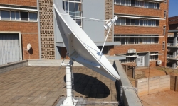
CSIR receives eStation to utilize Earth Observation data for environmental management
The Council for Scientific and Industrial Research (CSIR) – through the Marine and Coastal Operations for Southern Africa (MarCOSouth) consortium – has received one of 12 Global Monitoring for Environment and Security (GMES) and Africa programme eStations that enable access to critical Earth Observation (EO) data.
The Council for Scientific and Industrial Research (CSIR) – through the Marine and Coastal Operations for Southern Africa (MarCOSouth) consortium – has received one of 12 Global Monitoring for Environment and Security (GMES) and Africa programme eStations that enable access to critical Earth Observation (EO) data.
The installation of the European-funded and African Union-managed GMES and Africa programme eStation will enable regional partners and various research, academic, and industry organisations access to EO data and the MarCOSouth portal (www.marcosouth.co.za) to support the implementation of sustainable development policies at continental, regional and national level.
Installation of the eStation at the CSIR Pretoria campus, a leading partner in the Southern African consortium MarCOSouth project, was completed in June 2021. The MarCOSouth project aims to maintain, further develop and provide a sustainable platform for local, institutional, human and technical capabilities across Southern African countries.
“The e-Station is an operational distributable open-source data processing tool that aims to build and strengthen capacities in Africa to receive, process, analyse and exploit EO data for environmental management. The e-Station collects data from various sources that include, among others, the EUMETSAT and Copernicus services,” says Riëtte Pretorius, CSIR project manager for the MarCOSouth project.
Copernicus is a European EO programme used to monitor the Earth using satellites and in situ sensors. It provides accurate, timely and easily accessible information to improve the management of the environment, understand and mitigate the effects of climate change and ensure civil security. EUMETSAT provides data, products and support services to the Copernicus information services and user communities, with a focus on marine life, the atmosphere and climate.
The e-Station installation consists of an outdoor and indoor unit. The outdoor unit is an antenna that allows for the reception of the EUMETCast – Africa data. The indoor unit consists of an acquisition subsystem in the form of a personal computer that operates as the receiver of the EUMETCast data and an uninterrupted power supply, as well as other necessary peripherals. The e-Station (a part of the indoor unit) consists of a personal computer that is responsible for the acquisition and processing of the data and one that is responsible for the visualisation and sharing of the data.
“Each of the eStation computers has a EUMETCast key unit for the decryption data keys, as well as the TELLICAST software that allows for the decoding of frames and reconstruction of the files,” says Pretorius.
There is currently no other active eStation for marine and coastal applications in Southern Africa. The Spatial Information Systems Research Group will host a workshop on the eStation/EUMETCast capability for the wider CSIR EO community soon. Details will follow.


